


Indo Bangladesh Water Relations By Maj Gen AK Chaturvedi, AVSM, VSM (Retd)
![]()
Geography of Bangladesh
Large parts of Bangladesh are in the low-lying Ganges Delta.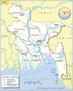 The delta is formed by the confluence of the Ganges (local name Padma), Brahmaputra (Jamuna), and Meghna rivers and their tributaries. The delta plain occupy 79 percent of the country. Four uplifted blocks (including the Madhupur and Barind Tracts in the centre and northwest) occupy 9 percent and steep hill ranges up to approximately 1,000 metres (3,300 ft) high occupy 12 percent in the southeast (the Chittagong Hill Tracts) and in the northeast. Straddling the Tropic of Cancer, Bangladesh has a tropical monsoon climate characterised by heavy seasonal rainfall, high temperatures, and high humidity.
Map-1: Bangladesh
Source: https://www.nationsonline.org/oneworld/map/Political-Map-of-Bangladesh.htm
Bangladesh has the largest network of rivers in the world with a total number of about 700 rivers including tributaries, which have a total length of about 24,140 km. They consist of tiny hilly streams, winding seasonal creeks, muddy canals (khals), some truly magnificent rivers and their tributaries and distributaries. However, The watercourses of the country are not evenly distributed. They increase in numbers and size is from the North West of the Northern region to the South East of Southern region. In fact in some places in South; such as Patuakhali, Barisal and Sundarbans area the watercourses are so many that even normal communication is through rivers. Bangladesh has predominantly four major river systems – (1) the Brahmaputra-Jamuna, (2) the Ganges-Padma, (3) the Surma-Meghna, and (4) the Chittagong Region river system.
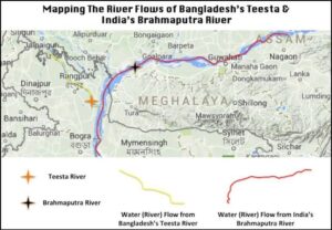
Brahmaputra (2850 km of length) originates in Tibet and after passing through the states of Arunachal Pradesh and Assam of India enters Bangladesh where it is known as Jamuna. Jamuna is joined by the Teesta River. The Teesta earlier ran due south from Jalpaiguri in three channels, namely, the Karatoya to the east, the Punarbhaba in the west and the Atrai in the centre. The three channels possibly gave the name to the river as Trisrota, which has been corrupted to Teesta. During 18th Century the Karatoya river had a confluence with Padma near Jafarganj but after the floods in 1787, the course of Teesta changed and with the new alignment running South East it joined the River Jamuna. Below the Teesta, the Brahmaputra splits into two branches. The western branch, which contains the majority of the river’s flow, continues due south as the Jamuna and after traversing 292 km in Bangladesh merges with the River Padma and the Eastern branch, formerly the larger but now much smaller, is called the Old Brahmaputra (Bromhoputro). It curves southeast to join the Meghna River near Dhaka.
Ganges originates in the state of Uttarakhand India (Length 2510 km) and after entering Bangladesh is known as Padma. Before the late 12th century the Bhagirathi-Hooghly distributary was the main channel of the Ganges and the Padma was only a minor spill-channel. The main flow of the river reached the sea not via the modern Hooghly River but rather by the Adi Ganga. Between the 12th and 16th centuries the Bhagirathi-Hooghly and Padma channels were more or less equally significant. After the 16th century the Padma grew to become the main channel of the Ganges. It is thought that the Bhagirathi-Hooghly became increasingly choked with silt, causing the main flow of the Ganges to shift to the southeast and the Padma River. By the end of the 18th century the Padma had become the main distributary of the Ganges. One result of this shift to the Padma was that the Ganges now joined the Jamuna (Brahmaputra as it is known in Bangladesh) and thereafter Meghna River before emptying into the Bay of Bengal. The present confluence of the Ganges and Meghna was formed very recently, about 150 years ago. River Padma forms the western boundary between India and Bangladesh for about 145 km before entering Bangladesh at the Northern edge of the Kushtia district of Bangladesh. It now flows South Eastward 113 km and joins Jamuna River near Goalundo Ghat /Rajbari. The combined flow of those two rivers constitutes the lower segment of the Padma, which continues to flow South Eastward through central Bangladesh to join the Meghna River near Chandpur and thereafter takes the name Meghna and empties into the Bay of Bengal through a 350 km wide Ganges Delta.
Map-2: River Ganges from Origin
Source: https://en.wikipedia.org/wiki/Ganges#/media/File:Ganges-Brahmaputra-Meghna_basins.jpg
The third major river system is the Surma-Meghna River System, which flows from the North Eastern border with India to Chandpur, where it joins the Padma. The Surma-Meghna, at 669 kilometres by itself is the longest river in Bangladesh. It is formed by the union of six lesser rivers. Below the city of Kalipur it is known as the Meghna. When the Padma and Meghna join together, they form the fourth river system; the Padma-Meghna river system; which flows 145 kilometres to the Bay of Bengal.
There is yet another River System; unconnected to the other four. It is the Karnaphuli River system. It flows through the region of Chittagong and the Chittagong Hills, cuts across the hills and runs rapidly downhill to the West and South West and then to the sea. The Feni, Karnaphuli, Sangu, and Matamuhari: an aggregate of some 420 kilometres —are the main rivers in the region. Of these rivers Feni is going to be relevant for further discussion on India Bangladesh water relations.
India Bangladesh Water Issues
Overview– The eastern Himalayan transboundary river system is primarily divided into two river basins – the Ganga (shared between Nepal, India, and Bangladesh, with few headwaterslike Karnali (known as Ghaghara in India), Arun, Sun Koshi, Trishuli in China) and the Brahmaputra (shared between China, India, Bhutan and Bangladesh). In this case, it is relevant to appreciate that the water resources of Indian Sub-Continent are monolithic i.e., unitary by geography but divided by political history. Be as it may, today India and Bangladesh (known as East Pakistan until 1971) share 54 transboundary rivers. First and the major one of these is River Ganges. It forms a boundary of 145 kilometres between India and Bangladesh. At Pakaur in India, the river branches of in two streams; The Bhagirathi River which goes on to form the Hooghly River the other stream which is actually is the main stream goes towards Bangladesh and becomes Padma River after entering Bangladesh. It flows for 113 km in Bangladesh before its confluence with Jamuna (the main stream of Brahmaputra is known as Jamuna in Bangladesh).
Dispute- Despite a long history of contestations, negotiations an Indo Bangladesh Joint River Commission was formed in 1972 in accordance with the provisions of the Indo Bangladesh Treaty of Friendship, Cooperation and Peace signed on 19 Mar 1972, as an institutional arrangement to study the river flow and develop the river waters on a cooperative basis. However internal political dynamics in both India and Bangladesh have led to estrangement despite the fact that the two countries have ample opportunities for cooperation, especially over water issues. Disagreements have also emerged in relation to India’s resistance towards information-sharing and concerns over ecological impacts in Bangladesh due to upstream water withdrawals by India. The water sharing disputes between India and Bangladesh have time and again strained the relations between the two. These disputes are mainly related to the Ganges, Teesta Rivers and Tipaimukh dam. Over a period of time the bilateral dialogues have been relegated to diplomatic agreements without substantive changes in infrastructure and operations on the ground.
Farakka Barrage-
• Background– It is a barrage across the Ganga river located in Murshidabad district of the Indian state of West Bengal, roughly 18 kilometres from the border with Bangladesh near Shibganj. Main objective of the Farakka Barrage Project is to divert adequate quantity of Ganga waters to Bhagirathi-Hooghly river system is preservation and maintenance of Kolkata Port by improving the navigability of the Bhagirathi-Hooghly river system. For this the barrage was necessitated to increase the lean period flow of the Bhagirathi – Hooghly River. The barrage diverts a large quantum of water during the winter season with a view to increase the water depth at the Kolkata port which was becoming increasingly unusable due to siltation. The increased upland supply from Ganga at Farakka into Bhagirathi was expected to reduce the salinity and ensure sweet water supply to Kolkata and surrounding areas without mechanical dredging. It was anticipated that the flow of water would be strong enough to flush out the silt and keep the port clear. It would also reduce the frequency and intensity of great tidal waves which move up the Hooghly, affecting ships going up and down from Calcutta port, reduce the content of silt in the water at Calcutta and thus improve navigation in the Ganga and reduce flood hazards in the catchment areas of river.Besides, it is also designed to improve communication, drainage, sanitation and water supply facilities in Calcutta as well as to provide inland transport throughout West Bengal with a rail and road bridge over the Farakka. The rationale of barrage was also linked with the intended benefit to the people of the city. Since the operation of Calcutta port directly affects the well-being of over 100 million people in hinterland which is much more than the total population of Bangladesh it was also assumed that the case for construction was legally also strong in India’s favour. Further, the rationale of saving Calcutta city and port impinges upon the economy of as many as 13 states of India. The utilization of Ganga waters by India for various industries affect the lives of a large segment of Indian society. Considering all the above reasons Indian government decided to build a barrage across the Ganga at Farakka, a few miles away where the Ganga branches into Bhagirathi.
• Accordingly, The rail-cum-road bridge was alsoplanned across the river Ganga at Farakka, which establishes a direct road and rail communication link to the North-Eastern Region with rest of the country. The Bhagirathi-Hooghly river system, the Feeder Canal and the Navigation Lock at Farakka form part of the Haldia-Allahabad Inland Waterway (National Waterway No:1). The Feeder Canal also supplies water to 2100 MW Farakka Super Thermal Power Project (FSTPP) of NTPC Ltd. at Farakka.
• Construction– commenced in 1962 and got completed in 1974 at a cost of $208 million. Operations began on 21 April 1975. The barrage is about 2,304 metres long. The Feeder Canal from the barrage to the Bhagirathi- Hooghly River is about 42 km long. The water diverted from the Farakka barrage is 1100 cubic meters per second of water from the Ganges to the Hooghly River which is less than 10% of Ganga river water available at Farakka.
• After the completion of the barrage in 1975, it was agreed by both India and Bangladesh to run it with specified discharges for period of 41 days from 21 April to 31 May during the remaining period of the dry season of 1975 under an accord announced in a joint press release on 18 April 1975. A short term agreement was subsequently signed by India and Bangladesh to conduct a 40 day trial test of the barrage during the dry season. But after the assassination of Sheikh Mujibur Rahman on 15 August 1975, relations between the two became greatly strained. As such no review was done but India continued to withdraw water even after the agreed period. This led to a crisis situation in Bangladesh in the dry season of 1976 but India continued to divert water at Farakka unilaterally till 1977.
• An Analysis of the Objectives Set Out Initially– It has been found that the diverted water flow from the Farakka Barrage was not adequate to flush the sediment from the river satisfactorily. In addition, there are reports of land and bank collapses in the River Ganges due to the high level back waters of the Farakka Barrage. Substantial high land is already converted to low level river bed causing displacement of huge population.
• Bangladesh’s Objection to Farakka Barrage-The India-Bangladesh environmental conflict dates back to the early 1970s over Ganges and Teesta water sharing. Bangladesh feels that as a lower riparian country, has no control over those 54 river which they share with India. They further allege that the unilateral water diversion or withdrawal of water from transboundary or international rivers has been the long-standing policy of India. Without any agreement with Bangladesh it has embarked on constructing dams or diverting water from many transboundary rivers such as Teesta, Gumti, Khowai, Dharla, Dudkumar, Monu, etc. India had reportedly blocked rivers such as Muhri, Chagalnaiya, Fulchari, Kachu and many others that flow into Bangladesh from Tripura. Since the transboundary rivers are within the territory of India, it did not discuss or come to any agreement with Bangladesh on the blockage or diversion of waters of the rivers although the Indo-Bangladesh Joint River Commission (JRC) exists since 1972. India constructed the huge Farakka Barrage in 1975 in order to divert a portion of the dry season flow to increase the navigability of Calcutta port. Thereafter, when it went into operation in 1975, the fresh water supply of the Ganges decreased considerably with a number of consequent effects in the South-West part of Bangladesh. Especially agriculture, navigation, irrigation, fisheries, forestry, industrial activities, salinity intrusion of the coastal rivers, ground water depletion, river silting, coastal erosion, sedimentation, as well as normal economic activities have been adversely affected.
Progress on Accords
In 1977 a temporary accord was signed for water sharing for five year. A five-year agreement was the first major sharing arrangement of the Ganges waters, which was signed in November 1977 soon after India unilaterally carried out water withdrawal from June 1975 to November 1977. According to the 1977 Agreement, the water would be shared during the dry season from January to May, divided into 10-day periods. A schedule of dry season flows was established based on 75% availability of flow at Farakka from the recorded historical data between 1948 and 1973. An important feature of the 1977 Agreement was a guarantee clause which ensured Bangladesh received a minimum of 80% of the scheduled flow if actual flow at Farakka dropped to less than 80% of the flow specified in the schedule.
After the expiry of the treaty in 1982, two more short term agreements were concluded on water sharing until 1988. In October, 1982 a Memorandum of Understanding (MOU) was signed between the two countries for sharing dry season flow of Ganges at Farakka in 1983 and 1984. This MOU is followed by the understanding reached between the Prime Minister of India, Indira Gandhi and the President of Bangladesh, H. M. Ershad in the Delhi Summit in November 1982. There was no agreement for 1985 dry season. Hence, the President of Bangladesh and Prime Minister of India discussed the issue during the Common Wealth Summit at Nassau, Bahamas in October 1985. Consequently in November 1985, another MOU was signed for three years by the two countries which expired on 31st May 1988.
After the expiry of MOU of 1985, no agreement was signed till 1996 in spite of the efforts by the two countries. In October 1993, Bangladesh raised the issue at Common Wealth Summit held at Cyprus and again in October 1995 at 50th UN General Assembly about the miseries of Bangladeshi people due to unilateral water diversion at Farakka Barrage. It also raised the issue at SAARC Summit meeting but failed to achieve any positive result.
However as a lower riparian state, Bangladesh negotiated with India and on 12 Dec 1996 the India-Bangladesh Treaty on Sharing of the Ganges Waters, a thirty-year treaty valid until 2026 was signed, which is hailed as a successful foreign policy initiative and is aimed at enhancing cooperative water allocation between the two neighbours.
The treaty envisaged that the water of the Ganges river would be distributed from Farakka between the two countries from 1 January to 31 May of each year and that India was required to maintain the flow of Farakka at the average level of the previous 40 years including any critical period when Bangladesh would continue to receive 35,000 cusecs of flow. The Annexure-I of Article-II, of the 1996 treaty establishes the formula for water sharing of the Ganges waters at Farakka during the dry season whereas Annexure II provides an indicative schedule of the sharing arrangement based on 10 days period average availability of water at Farakka for 40 years between 1949-1988.
Table-1: Water sharing formula of the 1996 Treaty (Article II, Annexure I)
Table-1: Water sharing formula of the 1996 Treaty (Article II, Annexure I)
| Availability at Farakka (m3/Sec) | Share of India | Share of Bangladesh |
| 1982 or less | 50% | 50% |
| 1982 to2124 | Balance of flow | 991 m3/sec |
| 2124 or more | 40,000 cusecs | Balance of flow |
On the ground, the treaty has achieved some level of success in sharing water in the lean season, though other provisions such as augmenting water availability in the Ganga at Farakka (where the Hooghly distributary to Kolkata emanates) remain unfulfilled. The focus of the treaty remains solely on water sharing, instead of taking a holistic view on the value and uses of the river. The draw back with the treaty, as mentioned by a lot of people in Bangladesh is that, It did not contain any guarantee clause for unconditional minimum amount of water to be supplied to Bangladesh, the treaty did not specify about the water-sharing arrangement for the period if the flow at Farakka falls below 1145 m3/sec, it has no provisions for clear dispute resolution mechanism and finally it is silent on arrangements for long term solution of the dry season water scarcity. The treaty also does not take into account future hydrological parameters. It may be noted that lower levels of soil moisture along with the increased salinity may also lead to desertification . On the other side, India complains that the water allocated to Bangladesh leaves it with less water than necessary for the functioning of Kolkata port and the National Thermal Power Corporation at Farakka.
However, since the Treaty ensures an equitable allocation and obligation not to cause significant harm of international laws through the inclusion of principles of equity, fairness and no harm to either party, it was considered a major breakthrough and it was hoped that it would reduce the probability of the conflict and promote cooperation between the two nations. The hopes were well-founded because finally it did manage to ease the tensions between the two countries. Even Begum Khalida Zia who was the leader of opposition and who had threatened that her party would abrogate the treaty when they would come to power but they also did not do that.
 Teesta River Dispute
Map-3: Teesta River
Source: https://www.insightsonindia.com/2020/08/24/teesta-river-dispute/
The Teesta river, a tributary of the Brahmaputra, originates in the Teesta Kangse glacier at 7068 metres in Sikkim and flows through the state of Sikkim and West Bengal before entering Bangladesh. It travels through 45 km of irrigable land before merging with Jamuna. It has been mired in conflict since 1947 when the catchment areas of the Teesta were allotted to India. The dispute started becoming serious when West Bengal government began constructing barrages on the river in 1979 mainly for irrigation purposes. As the upper riparian country, India controls the flow of water into Bangladesh from the Teesta Barrage at Anzaldua in Jalpaiguri, constructed to provide water to the northern part of West Bengal. Bangladesh has also constructed a barrage downstream at Dalia in Lalmonirhat District, which supplies water for agriculture and irrigation to drought prone areas of the northern Bangladesh. It was argued by Bangladesh that the construction of Gazaldoba barrage and the diversion of waters have drastically reduced water availability at Dalia barrage particularly in the dry season. It also needs to be needed that India has about 26 hydroelectric projects mainly in Sikkim producing 50,000 MW. Bangladesh Government opposed it and argued that the major rice producing areas of Bangladesh specially ‘rice bowl’ of Rangpur region lie in the Teesta and Brahmaputra river basin. The barrages constructed, are leading to scarcity of water for irrigation and low rice production. After the setting up of the India-Bangladesh Joint Rivers Commission in 1972 to pacify Bangladesh, India began negotiations on the issue. In 1983, an adhoc agreement on water sharing was concluded between India and Bangladesh. As per this adhoc arrangement India to receive 39 percent of the water and Bangladesh 36 percent. The Teesta river issue assumed significance after the conclusion of the Ganga Water Treaty in 1996. Negotiations between India and Bangladesh on the sharing of the river waters began soon after the signing of Indo Bangladesh Ganges water Treaty of 1996, but have made limited progress. The point of dispute is about unallocated 25% during adhoc sharing of waters was demanded by Bangladesh on equitable distribution basis.The commission recommended to increase Bangladesh’s share on logic that West Bengal’s barrage is very close to Bangladesh border (nearly 90 Kms.). Some water will penetrate underground and benefit both countries.
In 2010, the Prime Ministers of India and Bangladesh issued a joint communiqué calling for the Teesta issue to be resolved expeditiously. The two countries prepared a draft agreement on the Teesta and the statement of principles for sharing river waters in the lean season. These documents were to form the basis of an interim agreement on the Teesta between India and Bangladesh. As per the proposal of the agreement of 2011, the two sides had agreed to share the river’s water 50:50. Bangladesh’s argument was based on the historically at Rangpur 5000 cusecs was received which in lean period now gets reduced to 500 cusecs. India was agreeable to the ratio of 42.5 % for India and 37.5% for Bangladesh. But the proposal was opposed by the CM of the West Bengal on the ground that it will result into drying out of about one lac hectare land of at least five districts in the northern region of West Bengal and hurt Indian farmers. She also stated that in 1998, Bangladesh’s largest irrigation project ‘Teesta Barrage’ had already begun. With the help of this water, Bangladeshi farmers have already been three cropping season per year. Therefore, they do not deserve more water. Based on the objection of the CM of the West Bengal, The PM of India Therefore, had to drop the Teesta accord. It was very much criticized in Bangladesh. The view of the CM of West Bengal was that the volume of water in Teesta is decreasing and that it should be shored up by connecting it with some out of 54 rivers which flow from India into Bangladesh. One such river is Torsa, which is closer to Bangladesh border and Padma River. She recommended that a commission can be set to study this option. This proposal indeed has merit and probably will be a ‘Win-Win’ case for both the countries. It is appearing that Bangladesh is ready to soften their stand because of increasing pressure at home. In June 2015 Prime Minister of India Modi visited Bangladesh with Mamata Banerjee, Chief Minister of West Bengal and expressed confidence of finding a fair solution to the long pending Teesta water issue, crucial for Bangladesh, especially in the leanest period from December to March when the water flow often temporarily comes down to less than 1000 cusecs from 5000 cusecs. He said confidently that a fair solution of Teesta river water would be reached soon. Ms. Mamata Banerjee also reassured Bangladesh that an unfair deal would not be concluded on water sharing. Water of Teesta is very important for both India and Bangladesh as increasing dry season paddy in West Bengal as well as Rangpur has raised the water demand in the basin.
The sharing of the Teesta waters has been a long standing demand of Bangladesh since the livelihood of millions is attached to the river’s water.Its flood plain covers about 14% of the total cropped area of Bangladesh and provides direct livelihood opportunities to approximately 73% of its population. Moreover, building of a number of dams along the Teesta in Sikkim has resulted in lean seasonal flow draining into Bangladesh. Since Bangladesh is a lower riparian country, it is naturally sensitive about transboundary river issues, and the sharing of the Teesta waters currently holds the key to improved India-Bangladesh relations.
Bangladesh holds the view that India has consistently shied away from addressing the Teesta water issue.Due to India’s intransigence, Bangladesh had attempted to cultivate China and was “considering a proposal from China to plough in $1 billion to dredge and embank large portions of the Teesta River so that it formed a single manageable channel.” India had opposed the project since it did not want Chinese technicians close to the “Chicken Neck” corridor near Siliguri that links mainland India to its northeast.It is in India’s interest to conclude the Teesta water sharing agreement before Bangladesh and China’s finalise the deal to dredge the Teesta. It will be a part of China’s Belt and Road Initiative (BRI). Dhaka is walking a diplomatic tightrope while it attempts to maintain cordial relations with both Beijing and New Delhi. Sheikh Hasina wants to conclude the Teesta agreement to appease her domestic audience. Sheikh Hasina has been viewed as “pro India” by Bangladeshis and it is important for her political future that the agreement goes through. Also a bit of large heartedness on the part of India will create a ground swell in the citizenry of Bangladesh and ally their apprehension of Indian hegemony. A deal after Land Boundary Agreement of 2014 will cement further in the minds of average Bangladeshi that India is their all-weather friend.
Tipaimukh Dam

Map-4: Location of Tipaimukh Dam
Source: Modified by the Jaya thakur of ORF from Nishat et al,2014
Tipaimukh Dam is an proposed embankment dam on the River Barak in Manipur state of India. The main Barak river rises in the Manipur Hills near Liai Kullen village of northeast India as the Barak River and flows west becoming the Surma and Kushiyara River and then flows south as the Meghna River (after the two former rivers join again near the north of Bhairab Bazar) to the Bay of Bengal. The Barak- Meghna basin covers parts of India, Bangladesh and Myanmar. It has a total area of 82,000 sq.km ofwhich47,000sq.km. (or 57 percent of the total area) is located in India and 35,000 (43 percent of the total area) is in Bangladesh.
Historical Perspective of the Dam– The idea of a dam on Barak as a flood control measure for the Cachar plains first emerged in 1926. It is on record, however, that a barrage on the Barak river was discussed by India and Bangladesh at the first meeting of the Joint Rivers Commission held in New Delhi in June 1972. n that meeting, a storage reservoir on Barak River was envisioned for managing flood situation in parts of Assam and Sylhet. India and Bangladesh decided to assess the flood situation jointly for the project. The proposed site of the dam was finalised as the Tipaimukh village in Churachandpur district in Manipur in 1974. In 1978, it was decided that “the concerned Superintending Engineers of the two countries should jointly examine the scope of the Indian scheme of storage dam on Barak river at Tipaimukh.” It was further added that the “potential flood control and other benefits (particularly power) to Bangladesh should be studied expeditiously. In the following two decades, Tipaimukh took a back seat. After decades of deliberation on how to control flooding of the Barak and meet additional needs of energy generation, in 1999, the Tipaimukh hydroelectric project was approved and its construction entrusted to the North Eastern Electric Power Corporation Limited (NEEPCO). It will cause submergence of 303.20 sq km. The dam may also affect the eco system of the river. The proposal of the dam and reservoir created concerns over the availability of water for fishing and agriculture especially in the Sylhet Division of Bangladesh as well as sustenance of the Haor ecosystem which are a Ramsar sites. An analysis of water being discharged from various tributaries emanating from Meghalaya and Tripura is just about 11.66 % in the month of May. It is possible that water availability at Fulertal may get affected and that may be the reason for Bangladesh’s objection. The Indian government appears to be serious about developing hydropower in the North Eastern states. Tipaimukh is one of the largest project, on which work is stalled since 2008 due to rejection by the Forest Advisory Committee. However, it would be prudent if aspects of biodiversity and the local resistance and objections of Bangladesh are taken into account.
Purpose of the Dam-These are flood control and hydroelectric power generation.
Technical Details– The dam is planned to be 390m long and 162.8m high, across the Barak River, which enters Bangladesh downstream of the proposed dam location. The dam’s crest elevation will be at an altitude of about 180 m. above mean sea level, with a maximum reservoir level of 178 m. The dam was originally designed for flood control, to contain waters in the lower Barak valley. Hydro-power generation was later incorporated into the project. The project will have an installation capacity of 1500 MW, supplied by six 250 MW Francis turbine generators.
Issues Related to the Dam-
• It has been subjected to repeated delays as the project developed, as there has been controversy between India and Bangladesh over water rights, in addition to questions of environmental effects of the huge project, as well as the need to relocate indigenous Hmar people to make way for a vast reservoir.In 2013, the governments of India and Bangladesh announced further delays, as the Bangladesh decided to undertake additional studies about the likely impact of the dam and the mitigating measures which they would be required to undertake.
• Having agreed earlier, now Bangladesh is saying that the dam will disrupt the seasonal rhythm of the river and will have an adverse effect on downstream agriculture and fisheries. The government of Bangladesh has decided to send an expert team to the dam area to examine the features and likely impact of the dam on the flow of water into the Surma and the Kushiara. In 2013 the two governments announced up to a 2-year delay, to allow Bangladesh to complete additional environmental studies.
• Second limiting factor is that its proposed location lies in an ecologically sensitive and topographically fragile region. It is within one of the most seismically volatile regions on the planet. A major earthquake of magnitude of 6.6 on the Richter Scale rocked the Manipur-Myanmar border on 6 August 1988 with at the epicentre 240 km North East of the Dam site.
• Third limiting factor is that the region is situated in one of the biodiversity hotspotsof not only India but the world.
• It is also the home of the Hmar people, part of the Kuki tribe,whose cultural identity and very lives are intertwined with the river. They are opposing the dam, saying it would destroy their lives.
Some Related Issues
Infirmities of Bangladesh Water Governance– It has been claimed by knowledgeable people in Bangladesh itself that though Bangladesh has the highest per capita freshwater available at its disposal among South Asian countries, but due to very poor internal water governance practices, it can hardly make proper use of it . According to a survey conducted by the Bangladesh Water Development Board (BWDB), there are three hundred and ten rivers in Bangladesh. Out of these, fifty-seven are border rivers, the condition of one hundred and seventy five is miserable, and sixty five are almost dead. Eighty percent of the rivers lack proper depth. The latest study of Bangladesh Inland Water Transport Authority (BIWTA) reveals that one hundred and seventeen rivers are either dead or have lost navigability. Such rivers have big names like Brahmaputra, Padma, Mahananda, Meghna, Titas, Dhaleswari, Bhairab, Sitalksha, Turag etc. The reasons for this dichotomy are; absence of a combined and comprehensive water use policy, inadequate regulatory measures, poorly structured institutions; their inefficient performance; lack of coordination among them and finally lack of participation of the stakeholders in the implementation of projects. No wonder to hide their own infirmities authorities show an uncompromising attitudes during discussions for agreements. As far as ground water is concerned; in most places of North Bengal, hand-driven tube-wells have become dysfunctional because the water level has fallen beyond the extractable limit. Along with this, arsenic pollution and salinity intrusion has added a new dimension to the water crisis in Bangladesh. Yet another issue to ponder is that Bangladesh has too much water during the monsoon season but too little during the lean season.
Other Aspects related to water cooperation between India and Bangladesh– The framework agreement for greater cooperation in water management signed by the prime ministers of India and Bangladesh in 2011 remains largely on paper . In recent times, political and diplomatic efforts have sought to resolve pending issues on sharing of the Teesta and Feni rivers. While some success for the Feni has been achieved through the recent signing of an MoU between India and Bangladesh , the Teesta Accord remains a distant dream due to objections raised in the Indian state of West Bengal bordering Bangladesh. Unlike these water-sharing challenges, India and Bangladesh have managed to successfully co-operate on inland navigation and trade connectivity of the Brahmaputra under the Protocol on Inland Water Transit and Trade, 2015, though the tremendous potential to jointly develop river ways to enhance economic and people-to-people links remains severely limited due to extreme political sensitivity around sharing river water.
Other Aspects related to water cooperation between India and Bangladesh- Following aspects are relevant:-
• The framework agreement for greater cooperation in water management signed by the prime ministers of India and Bangladesh in 2011 remains largely on paper . In recent times, political and diplomatic efforts have sought to resolve pending issues on sharing of the Teesta and Feni rivers. While some success for the Feni has been achieved through the recent signing of an MoU between India and Bangladesh , the Teesta Accord remains a distant dream due to objections raised in the Indian state of West Bengal bordering Bangladesh. Unlike these water-sharing challenges, India and Bangladesh have managed to successfully co-operate on inland navigation and trade connectivity of the Brahmaputra under the Protocol on Inland Water Transit and Trade, 2015, though the tremendous potential to jointly develop river ways to enhance economic and people-to-people links remains severely limited due to extreme political sensitivity around sharing river water.
• The framework agreement for greater cooperation in water management signed by the prime ministers of India and Bangladesh in 2011 remains largely on paper . In recent times, political and diplomatic efforts have sought to resolve pending issues on sharing of the Teesta and Feni rivers. While some success for the Feni has been achieved through the recent signing of an MoU between India and Bangladesh , the Teesta Accord remains a distant dream due to objections raised in the Indian state of West Bengal bordering Bangladesh. Unlike these water-sharing challenges, India and Bangladesh have managed to successfully co-operate on inland navigation and trade connectivity of the Brahmaputra under the Protocol on Inland Water Transit and Trade, 2015, though the tremendous potential to jointly develop river ways to enhance economic and people-to-people links remains severely limited due to extreme political sensitivity around sharing river water.
Shadow of China on Indo Bangladesh Water Relations
The involvement of China in Indo Bangladesh water relations is based on journey of Brahmaputra for 1625 km in Tibet as Yarlung Tsangpo, 918 km in India (in the states of Arunachal Pradesh and Assam), initially as Siang and thereafter as Brahmaputra and thereafter 357 in Bangladesh as Jamuna.
A number of hydropower projects on the Chinese side of River Brahmaputra are a cause of concern for India. In January 2013, China announced as part of their 12th Five Year Plan (2011-15) three hydro-electric projects. These projects were in addition to Zagmu project located in Tibet. Out of these Zagmu with the capacity of 510 MW, got completed in 2015. Second, at Jiacha with a capacity of 320 MW got completed in Jul 2020. Other two at Dagu of capacity 640 MW and Jiexu of capacity 560 MW, upstream of Zagmu are in various stages of construction. Although, China assured India that these dams will not affect flood control, disaster mitigation and ecology in the downstream areas, but India considers them as potential weapons against lower riparian states. In this connection though it is said that these dams will be run of the river type dams but to run the turbines for such huge power requirements huge storage reservoir will have to be constructed. India also apprehends that with these dams, China will able to divert waters of River Brahmaputra to its parched northern parts through the South-to-North Water Transfer Project. Here it is to be noted that though China through a MoU has agreed to supply hydrological data with respect to Brahmaputra and Sutlej to India at a cost of around Rs 1 crore since 2002. The measuring stations on Yarlung Tsangpo are located at Nugesha, Yangcun and Nuxia. With the measurement at Nuxia and Tsela Dzong as 5000 and 10000 cusecs respectively, China is trying to convey that there is no stealing of water by them. However here lies the flaw. In this connection it needs to be noted that while some of the tributaries of Brahmaputra like Teesta, Dibang, Lohit, Subansiri which join Brahmaputra during its journey in India are glacier fed but Yarlung Tsangpo is essentially a rain fed river to which glaciers contribute only 13 %. Thus While precipitation is the largest contributor to the flow, rainfall is extremely varied across the basin. The Tibetan Plateau receives very little rainfall by virtue of its location on the north aspect of the Himalayan crestline. Comparatively, the rainfall in the part of the basin located in the south aspect of the crestline is much higher and the annual average precipitation (that includes mainly rainfall) may reach about 4,500 mm. This is in stark contrast to the average annual precipitation of about 300 mm in the trans-Himalaya, North of the crestline. Interesting part is that All the three gauging stations from which India gets the hydrological data are located in the rain shadow region on the North side of the crest line. To add insult to injury, after Doklam standoff in 2017 China has stopped sharing the data with India though they are still sharing it with Bangladesh with respect to Brahmaputra. Therefore, there is no doubt that China is diverting some water and it would become more when the fifth project comes up at Great Bend at Medog County with the capacity of 60 GW. By the way Nuxia gauging station is located West of this location.
 Map-5: Gauging stations on Yarlung Tsangpo (Brahmaputra)
Source: https://www.firstpost.com/long-reads/despite-india-china-bilateral-agreement-water-data-on-brahmaputra-might-be-inadequate-7889281.html
While it is true that as Brahmaputra moves from Indo- China Border it becomes more and more voluminous as more streams join it. As such, while total annual outflow of River Brahmaputra from China is estimated to be about 31 BCM, by the time it reaches Bhadurabad, the gauging station near the end of the rivers’ sub-basin in Bangladesh, its outflow is about 606 BCM. Even at Guwahati it is 494 BCM. However, fact remains that with all these dams, probability of China using stored water as a weapon cannot be discounted more so as the area is highly prone to seismic activities. Another aspect is that the dam which is coming up at Medog will result into a significant amount of the Yarlung Tsangpo/ Siang’s sediments getting trapped behind the walls of the dam and thus the released clear water down stream of the dam will increase the probability of erosion of the riverbank and riverbed, as has been observed in the case of the Three Gorges Dam, causing major damage to the biodiversity of the downstream area and the river bed.
Geopolitics of Water in China and India- Bangladesh Relations–
• It has been reported that China has built eleven mega-dams on the Mekong River, causing water levels there to fluctuate widely without prior notice to lower riparian states of Myanmar, Laos, Thailand, Cambodia and Vietnam.
• China is using its leverage over water flows as a stick to win concessions from South East Asian countries located downstream of the dam on other issues, including in regard to its Belt and Road Initiative. China is likely to use the same tactics with India with its proposed Yarlung Tsangpo Dam. It appears that this project is actually going to be a part of China’s design to add another dimension to the ongoing standoff with India by means of a ‘Water War’. In this connection it is relevant to note that China had been perfecting the technique to harness water for a long time.
Some analysts believe that the dam near Medog will have a potential to cause wide spread damage to areas downstream of the proposed dam in case it is used as a water bomb. In such a situation it is not only the Indian states of Arunachal Pradesh and Assam which will be affected but the volume of water is likely to be so much that even large area of Bangladesh would also be affected. Also these dams will give Beijing the ability to divert or store water in times of political crisis. This aspect of the proposed dam makes it yet another point of dispute between the two countries. If India also goes for the dam it may be a knee-jerk reaction and India will appear as much a violator of the UN Convention of 1997 with respect to the rights of Bangladesh. The only justification for the Indian action appears to be that the planning of the dam on Indian side and its early completion on the Indian side would strengthened the Indian claim on the waters of Siang and weaken the right of China to build the dam. However; Bangladesh is appearing equally concerned about the China’s dam as water in Jamuna (Brahmaputra/ Yarlung Tsangpo as is known in Bangladesh) is likely to get disrupted with the completion of all the three dams. Surface water is quite critical for Bangladesh because she substantially depends on surface water as her ground water is contaminated to a large extent.
Conclusion
The hydro resources in South Asia are so intertwined that their optimal utilisation can be done in a cooperative and collaborative manner only. We already have a highly workable model in front of us in the form of energy cooperation which has helped Bangladesh- Bhutan- India- Nepal (BBIN) Region to collectively prosper by sharing resources in an interdependent mode. A similar exercise needs to be done in the case of Hydro resources. Here also we have two examples of cooperation in the form of the Indus Water Treaty, between India and Pakistan, which is holding on for more than six decades and similarly the Indo Bangladesh Ganges Accord of 1996 which has been there for nearly 25 years.
However, India needs to become more sensitive to the water issues of not only Bangladesh but that of Nepal also. Some sort of rigidity on the part of India will allow China to quietly sneak in Bangladesh and Nepal and that would be detrimental to our national interests. In this connection we need to make a common cause with Bangladesh against Chinese dams in Tibet which are going to impact both Bangladesh and India. India also needs to resolve Teesta issue at the earliest so that Bangladesh Chinese contract for dredging Teesta in Bangladesh is scuttled. In this connection CM, West Bengal’s proposal to augment water supply to Padma and indirectly in Teesta by considering waters of River Torsa is worth considering. Tipaimukh Dam needs to be revisited due to Changed environmental conditions and also the resentment it is causing not only in Bangladesh but even in Manipur and Mizoram.
References:
1. http://en.banglapedia.org/index.php/River
2. Bangladesh Bureau of Statistics (BBS), Statistical Year Book of Bangladesh 1998, BBS, Dhaka, 1999.
3. https://www.britannica.com/place/Goalundo-Ghat
4. https://en.wikipedia.org/wiki/Geography_of_Bangladesh
5. Md Shariful Islam, “Bangladesh- India water sharing disputes: possible policy responses available on https://www.researchgate.net/publication/330512925_Bangladesh-India_Water_Sharing_Disputes_Possible_Policy_Responses
6. Dr. Aruna R Mital , “Indo-Bangladesh water sharing issues” Pub by International Journal of Humanities and Social Science Research Volume 2; Issue 11; November 2016; Page No. 07-11available on www.socialresearchjournals.com
7. Jaya Thakur, “India-Bangladesh Trans-Boundary River Management: Understanding the Tipaimukh Dam Controversy”, pub as an Issue Brief by the ORF in Jan 2020.
8. Anuttama Banerji, “India Must Settle the Teesta River Dispute With Bangladesh for Lasting Gains”, pub in The Diplomat 09 Apr 2021
9. INSIGHTSIAS available on https://www.insightsonindia.com/2020/08/24/teesta-river-dispute/
10. Arkamoy Dutta Majumdar, “Why Mamata Banerjee is opposed to sharing Teesta Waters” pub in Mint dated 11 Apr 2017, available on https://www.livemint.com/Politics/dtlGtxiSUVDJgo7eoBxxDL/Why-Mamata-Banerjee-is-opposed-to-sharing-Teesta-waters.html
11. Amit Ranjan, “China’s Hydropower Projects on River Brahmaputra”, ISAS Brief, dated 06 Aug 2020 and available on https://www.isas.nus.edu.sg/papers/chinas-hydropower-projects-on-river-brahmaputra/
12. Nilanjan Ghosh et. al., “Why India needs to buy better water data from China”, pub in Third pole dated 10 Jan 2020 and available on https://www.thethirdpole.net/en/regional-cooperation/why-india-needs-to-buy-better-water-data-from-china/
13. Maj Gen AK Chaturvedi, AVSM, VSM (Retd), “China’s Exploitation of Yarlung Tsangpo: Consequences for Lower Riparian States” pub by The Strive India on 25 Feb 2021 and available on https://striveindia.in/chinas-exploitation-of-yarlung-tsangpo-consequences-for-lower-riparian-states-2/
Disclaimer: The views expressed are those of the author and do not necessarily represent the views of the organisation that he belongs to or of the STRIVE.