


Attempts of China to Steal Water from the Lower Riparian States By Maj Gen AK Chaturvedi, AVSM, VSM (Retired)
![]()
 Introduction
The Tibetan plateau is believed to be having as many as 37000 glaciers on Chinese side[1]and an origin of a number of major rivers namely; Indus; Sutlej; Yarlung Tsangpo (Brahmaputra); Irrawaddy; Salween; Huang He; Yangtse; and Mekong[2]. China by virtue of having Tibet under its occupation is the upper riparian state in all the cases. These rivers flow into Pakistan, India, Myanmar and Laos and form the largest river run-off from any single location. It is estimated that the net hydrological output in Tibet is to the tune of 627 cubic km per year. This is about 34 percent of the total river water resources of India[3]. Before the occupation of Tibet by China, the entire quantum of this water used to flow into lower riparian states, however, nowadays, only 577 cubic km is transferred to lower riparian states.[4]China is going for a number of dams on various rivers originating in Tibet. While stated objective of all such dams has been that these are meant to generate power and use the water for irrigation purposes, but possibility of using the stored water as a weapon by the upper riparian state is always there. The 2004-05 Parichu incident[5], clearly shows that China is quite capable to use his advantage of being upper Riparian to weaponize the water. There is a UN Convention; namely; Convention on the Law of the Non- Navigational Uses of the International Watercourses of 1997[6]; which governs sharing of fresh water resources that is of universal applicability among the riparian states of a particular trans-border water channel. The key guiding principles of this convention are; an equitable and reasonable utilization of international water courses; an application of appropriate measures to prevent harm to other States sharing an international watercourse; and the principle of prior notification of planned measures. For the Convention to become legally binding, at least 35 nations need to ratify it. Needless to add that the People’s republic of China (PRC) has not ratified this Convention.
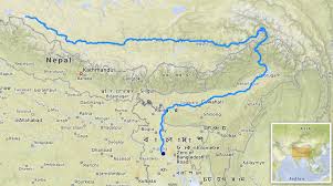
(Map-1: Rivers originating in Tibetan Plateau, Source: https://www.yowangdu.com/tibet-travel/where-is-tibet.html)
Options for China to Exploit the Waters from Rivers Originating in Tibet
As has been explained earlier, Tibet is the Water tower from which a number of rivers emanate, however, keeping in view the focus of this research the discussion would be restricted to those rivers for which India is one of the lower riparian state; namely Indus and River Brahmaputra(Yarlung Tsangpo; as it is known in Tibet).
China could exploit these rivers in three ways:-
- Blockage/ Diversion of the Rivers- In addition, to meet its irrigation and power needs, as per her ‘Five Years Plans’, the Chinese government has planned to build 120 gigawatts (GW) of new hydropower plants on the Salween, the Upper Mekong, Upper Yangtze and the Yarlung Tsangpothrough more than one new dam, which would be equal to Three Gorges Dam in capacity, every year for the next five years.[7]China is also making outreach to Pakistan-Occupied Kashmir (POK), where it has promised to finance and build five dams, which will form the ‘North Indus River Cascade’, which will have a potential to generate 22000MW of power[8]. These dams are coming up, from North to South at; Bunji; Diamar-Basha; Dasu; Patan at Thakot[9]. These dams will negatively affect the flow of water to lower riparian states, i.e.; India and Pakistan, especially in non-monsoon months. These dams will also impact the environment. China is also building five dams on Brahmaputra river, and it is suspected that they will try to divert the Brahmaputra (Yarlung Tsangpo)Northwards, to China at the u-bend”, before it enters India.[10] China has already blocked the flow of the Xiabuqu river, one of River Brahmaputra’s Tibetan tributaries, for the Lalho hydel project[11]. More recently, in the aftermath of border clashes between India and China in the Galwan Valley from May 2020, China had blocked the flow of the Galwan River, a tributary of the River Shyok, which itself is a tributary of River Indus which originates in the Chinese-occupied Aksai Chin area, thus altering the natural course of the river to prevent it from entering India[12]. In this connection, it is worth noting that in the absence of any dispute resolution mechanism about the common river water sharing, diplomatic negotiations are the only means to settle the disputes.
- China could Sabotage Transboundary Rivers by Polluting them, Rendering them Unfit for Use– The Siang river, which joins the Lohit and the Dibang downstream to form the Brahmaputra, turned muddy and “blackened” in 2017, raising concerns about China’s upstream activities[13]. The water became unfit for human consumption. This episode severely affected agriculture production in the Siang valley and it also had a detrimental impact on fishing. Although China tried to rationalise the changes based on the logic that an earthquake in November 2017 might have been the cause, but it could not be supported by the fact that the river course had got polluted well before the earthquake.
- China has Access to Valuable Data that can Help to Manage Foods and Fluctuations Downstream- India and China have signed two agreements since 2008 on data sharing for the Sutlej and Brahmaputra with a view to manage the shared watercourses[14]. While these agreements have had a positive impact on the water management and helped to pre-empt and control flooding, this dependence can also be exploited by withholding hydrological data accessible only to the upper riparian state. As is her won’t, China withheld hydrological data for Brahmaputra and Sutlej in 2017 in contravention to the agreement resulting into Assam, Himachal Pradesh, and Punjab ill-prepared for floods when they came. In fact, the Parichu incident mentioned earlier fell in the same category. In all fairness; while China remained cooperative and shared upstream data in advance with India at that time, there was speculation (after China rejected a request by India to send scientists and engineers to the site) that China had deliberately created a “ Liquid Bomb”, an artificial lake unleashed at will to potentially devastate downstream areas. It needs to be noted that the Parichu incident showed a way that China; at will; could use water as a weapon. Incidentally, data sharing has again commenced with effect from 2018[15].
 River Diversion Efforts of China
In this paper river diversion projects of only two rivers, namely; the Brahmaputra and the Indus, which originate in Tibet, are considered. The Indus originating in Tibet runs through Ladakh in India and thereafter into Pakistan, while the Brahmaputra originating in Tibet flows through Arunachal and Assam in India and thereafter into Bangladesh. Both are among the longest and largest rivers in the world ( (River Indus is 3180 km and River Brahmaputra is 3100 km). India is named after the Indus, as the word Hindu comes from it. This river is sacred to India’s Hindus and central to the evolution of India’s civilization. Both of these rivers flow from the Tibetan plateau into two Indian states that share border with Tibet Autonomous Region (TAR)ofChina. The Indus flows into the Union Territory of Ladakh, which has since May 2020 been the flashpoint of a conflict with China. The River Yarlung Tsangpo flows into Arunachal Pradesh, an Indian state that also shares a border with Bhutan and whose substantial territory, China claims as its territory (In 2006, the Chinese ambassador to India claimed that all of Arunachal Pradesh is Chinese territory amidst a military build-up. China’s territorial claim on the Indian state of Arunachal Pradesh has been a major bone of contention between India and China. China bases it claim on the argument that historical ties existed between the Tawang monastery in Arunachal Pradesh and the Lhasa monastery. Hence, the Chinese logic is that given Tibet is now part of China, Arunachal Pradesh should form a part of it[16].).For many years, China had planned to divert the Yarlung Tsangpo in Tibet[17], and the Indus from their place of origin to the arid areas in China’s Xinjiang.
Map-2: Alignment of IndusSource: https://en.wikipedia.org/wiki/Indus_Waters_Treaty
Autonomous Region[18]. China has adequate experience of the river diversion projects. China has already completed a river diversion project over a distance of 1400 kms, transferring water to its arid northern regions including the capital. The project entailed two 4,000-meter-long tunnels under the riverbed of the Yellow River to transfer water from the Yangtze River[19].
Map-3: Alignment of Brahmaputra Source: https://upload.wikimedia.org/wikipedia/commons/f/f8/Brahmapoutre.png
Diversion Tunnel for Transportation of Waters from River Yarlung Tsangpo to Xinjiang– Ren Qunluo, professor at the Xinjiang University of Finance and Economics is quoted as saying: “Water from rivers such as the Yarlung Tsangpo River can help in turning the vast deserts and arid lands into oases and farmlands, because Xinjiang has 1.1 million km2of plains, but less than 70,000 km2 are arable due to a shortage of water[20], hence need for diversions of waters

from rivers in South and East having surplus waters. As a media report claimed recently; Chinese engineers are testing techniques that could be used to build a 1,000km long tunnel—the world’s longest—to divert water from the Brahmaputra river in Tibet close to Arunachal Pradesh to the parched Xinjiang region[21]. Although Chinese foreign ministry spokesperson called the report untrue and assured that China would take into account the interests of downstream countries while going for any river training works, however keeping in view the past record of China[22], it would be naïve to believe Chinese assertions. However, another aspect which needs to be examined is as to whether China has the capability to make a tunnel of 1000 km for the carriage of water. Presently China’s longest tunnel is only 85 km and it is part of the Dahuofang water project in Liaoning province, while the world’s longest tunnel is the 137km main water supply pipe beneath the city of New York[23]. The final destination of the proposed tunnel from Yarlung Tsangpo is Xinjiang and the route is via Taklamakan desert,in which it would drop down from the world’s highest plateau in multiple sections connected by waterfalls and would provide water to China’s largest administrative division, comprising vast swathes of deserts and dry grasslands. The logic given by China for building the tunnel is that the Tibetan Plateau stops the monsoon from the Indian Ocean reaching Xinjiang, leaving the Gobi desert in the north and the Taklamakan desert in the south unsuitable for human settlement. The plan to divert Yarlung Tsangpo from Tibet to Xinjiang was first conceptualised by the Qing dynasty in the 19th century, but due to the project’s enormous cost and engineering challenges, as well as the river’s international status, the project remained a non-starter[24]. With newly acquired affluence and it’s status of big power; China has revived the project and to test the requisite technologies that will be replicated in Xinjiang; the Chinese administration has gone for a trial run in Yunnan Province since August 2017, where a 600 km long tunnel is being drilled for a water diversion project[25]. The Environmentalists are apprehending that such a move is likely to have an adverse impact on the Himalayan region. In this connection, it is worth noting that the Tibet Plateau has been witnessing climate change, with water crises in many parts of the Himalayan region. “The region is also earthquake-prone and it could lead to a huge natural disaster.”The recent deluge in Dhauli Ganga in Uttarakhand due to a glacier burst in the Nanda Devi glacier is a case in point, about the adverse impact of the Climate Change, aggravated due to active tectonics and deforestation[26].
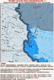
Map-4: Assessed Water Tunnel of Brahmaputra to Divert Water to Xinjiang Source:https://theprint.in/report/first-evidence-of-complete-brahmaputra-by-china/21694/
Pilot Project on Indus– There is also a thought process in China to go for a smaller ‘pilot’ project: to divert the Indus river towards Xinjiang. It is felt by planners in China that a small-scale project, with low investment and a quickly realizable scheme, could be an ideal pilot project. This diversion will be from the Indus river in Western Tibet to the Tarim Basin in Xinjiang before it enters Ladakh. The project is being referred as ‘the South Western part of Western Route Project’. It is felt that the diversion will help in maintaining long-term stability in Xinjiang. It could increase the total amount of water resources in the Tarim Basin, which is located in the hinterland of Taklamakan Desert and suffers from sand dune mobility. In this highly arid region, which receives low precipitations, water is extremely valuable. Xinjiang has 1.1 million km2 of plains equal in size to all the plains in China’s East. But less than only 70,000 km2 are arable due to a shortage of water. If these areas are greened then another prosperous geographical zone would have been created, which will have the potential to enhance China’s prosperity substantially. Those who are arguing for the project, say that technically it is feasible as Water would flow from the high Qinghai-Tibet plateau, at an elevation of over 3,000 [in fact 4,000] meters, and at the receiving end, water would be at only 1,500 meters above sea level. The research says that it would also curb the global warming and increase the rainfall in China. China feels that this diversion could help to curb the global warming for the entire humanity and as such there is a fair probability that it would get the global support. These planners are simply glossing over the fact that it will reduce the availability of water in lower reaches of Indus and that will cause irreparable environmental damage all the way up to and in Sind in Pakistan.
Incidentally, no study on the environmental impact has been carried out so far on either of the two projects. Also; though China denies both these projects but both these projects are there on their official websites. Can China be trusted on her word?
Impact on the Lower Riparian States
This project of water diversion by China involving the Brahmaputra has already become another point of tension between China and the two South Asian Riparian states, namely; India and Bangladesh. India, has already flagged its concerns to China about various dams being built by it on the Yarlung Tsangpo. Beijing has been assuring India, the middle riparian state and Bangladesh, which is the lower riparian state, that its dams were of the run of river projects and not designed to store water, however, they have not shared any design details of the dams with India. The proposed tunnel and its multiple sections will drop from the world’s highest plateau through a number of waterfalls. The tunnel project are in the blueprint stage and have already been submitted to the Chinese government for necessary sanction. It goes without saying that these projects are going to be disastrous for both India and Bangladesh and are likely to trigger a serious water crisis in India’s North East and thereafter in Bangladesh. However, the problem is that currently there are no water treaties between India, China, &Bangladesh, and to dissuade China from her unilateral action no formal dispute resolution mechanism exists. Therefore, India will be required to take a strong stand in conjunction with Bangladesh. The Chinese scientists and engineers are aware that India and Bangladesh would protest against the project, but they are going ahead to implement it, anyway.
In final analysis it can be concluded that the regional disparities existing within China are being attempted to be reduced at the cost of lower riparian states; particularly Pakistan in the West who will further get reduced to the status of a client state to China as desertification and further ingress of sea into lower reaches of Indus will affect the agricultural production in Sukkar Bowl with consequent adverse impact on the food security of the country. Also, The diversion of Indus could strengthen China’s actual control of Aksai Chin which will not be in line with the strategic interests of India. The significant aspect is that China does not take into account as to how the lower riparian states, in this case of pilot project; India and Pakistan and in the case of Brahmaputra Diversion; India and Bangladesh will get impacted.
Concern sparked by these diversion projects is heightened because China already has blocked the flow of a Tibetan tributary of the Yarlung Tsangpo, called the Xiabuqu River, for its Lalho Hydrel project as reported by the Economic Times. More recently, in the aftermath of border clashes between India and China in the Galwan Valley from May, China has blocked the flow of the Galwan River, a tributary of the Indus which originates in illegally occupied territory of Aksai chin by China, thus altering the natural course of the river to prevent it from entering India,” as reported by Ameya Pratap Singh and Urvi Tembey in an analysis published in the journal of Lowy Institute on July 23.
Between the Indus, which originates in the west of the Tibet plateau, and the Yarlung Tsangpo-Siang in the East, there are six major rivers flowing from Tibet to India, namely; Sutlej, Bhote Koshi; Arun; Trishuli; Karnali and Gandaki. These rivers are crucial for India’s agricultural and industrial needs. As of 2016, China had plans to build 32 dams on the rivers and tributaries, raising concerns among people in lower riparian states. Some of these are going to affect the water availability even in Nepal the middle riparian state and India, the lower riparian. China’s plans to divert two trans-Himalayan rivers that sustain millions in downstream regions in India, Pakistan, and Bangladesh and even Nepal are adding to India’s growing concerns due to simmering India China border tension.
Impact on Environment
The diversion will “disrupt biodiversity” and “increase chances of earthquakes (the Himalayas are located in high seismic zone) and floods.” Waghmare in his seminal work has highlighted the devastating effects of such projects in history. They include “the complete drying-up of the Lop nor salt lake, which, since the Qing era, was deliberately diverted, like the Tarim and Kongque rivers, to feed off oases aquifers and hilly runoffs, thus forming dry river beds, progressive desertification, and the destruction of sand-stabilizing tamarisks which otherwise contained erosion,” he said. He has further added, “As in Uzbekistan, erstwhile Soviet Union fixated with cotton production had damaged the environment forever (drying up of the Aral sea[27])”.[28]
Military Implications of Diversions
As the recent clashes on the Sino-Indian border have made it clear that India needs to assess China’s intent and capability to ‘weaponize’ its advantage over the lower riparian countries’, Singh and Tembey said. “Control over these rivers effectively gives China a chokehold on India’s economy,” Nagao says the river diversion project is strategically relevant, and India should be concerned, in the wake of the Galwan incident. He says that if China diverts the rivers in these sensitive areas, it would deploy the military to protect the projects, and any military build-up would add to the degree of difficulty for India and would offer China better reaction/ surprise capability. Both scenarios are a matter of concern for India. “This nightmarish scenario was evident in the recent standoff between India and China. For the development of water scare areas, pollution control of the high population density areas and for the growth of water-intensive manufacturing, China needs more water and as such China has started plans to divert the flow of the rivers,” Once again more construction of water holding structures in TAR would result into the deployment of more troops to safeguard those structures. Also, development of the area enhances its defence potential. As a result, China’s military activities in the India-China border (around Tibet) are likely to further increase.
Geopolitical implications
The aim of these projects will strengthen the integration of Xinjiang with rest of the country and may help to address the sense of alienation which Uyghur Muslims of Xinjiang (East Turkestan) are presently having. The unstated aim appears to be strengthening its control on Aksai Chin, which is critical for China to have connectivity between TAR and Xinjiang. However, China needs to be weary of three related issues. Firstly; She needs to realise that such a development will be detrimental to the border dispute resolution between India and China in Eastern Ladakh, secondly; diverting water from Indus may also impact Sino-Pak relations as a reduction in the water availability in the River Indus will adversely affect Pakistan also, who is, as it is, struggling with the scarcity of water and thirdly reduction in the volume of the water in Siang will affect Bangladesh also who is the lower riparian and it is a moot point; whether China at this stage will antagonise Bangladesh.
Way Ahead
To prevent Chinese incursions on the border and save water resources which India is authorised as a lower riparian state; India should work to generate awareness about the design of China in the comity of nations and particularly in conjunction with the other stake holder countries, namely; Pakistan; Nepal and Bangladesh, work out a diplomatic counter-strategy to nail China. In this regard help of countries like the USA, Japan, Australia, and countries of ASEAN, which have a strategic stake in the stability of the region should also be co-opted. The simultaneous need is to strengthen the defence capabilities in terms of improving the indigenous manufacturing capability of military equipment; strategic tie-up with like-minded friends and those who have strategic stakes in the stability of the region. To ward off the threat of Chinese poaching of her legitimate water resources; India should advocate the establishment of an international multilateral framework to decide the share of water resources. This is necessitated because a bilateral framework to share water with China or a framework involving affected lower riparian states of Pakistan and Bangladesh is likely to remain a non-starter, due to Chinese influence in those two countries. May be a grouping like QUAD ( India, Japan, Australia, and US) or QUAD Plus (QUAD countries plus Vietnam, South Korea and other countries of Mekong Basin) to counter power balance could be a way ahead. India also needs to challenge China based on Goal-6 (Clean water and sanitation) of the Sustainable development Goals (SDGs)of the 2030 Agenda for Sustainable Development — adopted by world leaders in September 2015 at a historic UN Summit which officially came into force on 01 Jan 2016; in various international Fora.
References:
- Gao Baiyu, “New concerns for transboundary rivers as China discusses diversion” by, January 14, 2020pub in The Third Pole.net https://www.thethirdpole.net/2020/01/14/new-concerns-for-transboundary-rivers-as-china-discusses-diversion/
- Manu Balachandran, ”China’s planning a 1,000km tunnel to divert water away from one of India’s largest rivers”, pub in quartz India dated 30 Oct 2017, uploaded on https://qz.com/india/1114843/chinas-grand-plan-for-the-brahmaputra-a-1000km-tunnel-to-divert-water-away-from-tibet/
- Claude Arpi, “Diverting the Indus River to Xinjiang: a ‘pilot’ project”,pub by Foundation for Non-Violent Alternatives: An Institute for Developing Peace Studies, dated 13 Dec 2o14 uploaded on: https://fnvaworld.org/portfolio-item/diverting-the-indus-river-to-xinjiang-a-pilot-project/
- Sutirtho Patranobis, “China plans 1000-km tunnel to take Brahmaputra water to Xinjiang: Report”, pub by The Hindustan Times, Beijing dated 30 Oct 2017
- “China Plans to ‘Turn Xinjiang Into California’ by Diverting Indian Rivers, Experts Say “, Published by The Epoch Times dated 02 Oct 2020, uploaded on http://idrw.org/china-plans-to-turn-xinjiang-into-california-by-diverting-indian-rivers-experts-say/.
- Maj Gen AK Chaturvedi, “Water a Source of Future Conflicts”, pub by Vij Books India Private Limited Delhi dated 2013
[1]Brook Larmer, “The Big Melt”, pub in the National Geographic Magazine in April 2010.

[2]China, Tibet and Strategic Power  of Water, pub in Circle of Blue/ Water News dated 08 May 2008 and uploaded on https://web.archive.org/web/20080702122515/http://www.circleofblue.org/waternews/world/china-tibet-and-the-strategic-power-of-water/

[3]“Introduction to water resources of Tibet”, pub in Tibet Nature Environmental Conservation Network dated 02 Jun 2014 and uploaded on https://tibetnature.net/en/introduction-water-resources/

[4]“Introduction to water resources of Tibet”, pub in Tibet Nature Environmental Conservation Network dated 02 Jun 2014 and uploaded on https://tibetnature.net/en/introduction-water-resources/

[5]In 2004, an artificial lake on the Parichu stream (a tributary of the Spiti in Tibet) caused floods after a landslide, leading to heavy loss of life in the Sutlej and Spiti valleys. In 2005, flash floods in the Sutlej Valley at Kinnaur again turned the attention towards the artificial lake.

[6]https://legal.un.org/ilc/texts/instruments/english/conventions/8_3_1997.pdf

[7]Beth Walker, “China plans more dams and mega infrastructure in Tibet” pub by The Third Pole dated  21 Mar 2016 uploaded on https://www.thethirdpole.net/en/climate/china-plans-more-hydro-projects-and-mega-infrastructure-in-tibet/

[8]An IANS Report, “Chinese funded North Indus river cascade a Himalayan blunder for Pakistan”, pub in Business Standard dated 22 May 2017

[9]Joydeep Gupta, “Indus Cascade a Himalayan Blunder”, pub in The Third Pole dated 22 May 2017, uploaded on https://www.thethirdpole.net/en/climate/indus-cascade-a-himalayan-blunder/

[10]Maj Gen AK Chaturvedi, “China’s Exploitation of Yarlung Tsangpo: Consequences for Lower Riparian States”, pub by StriveIndia.in dated 28 Jan 2021 uploaded on https://striveindia.in/chinas-exploitation-of-yarlung-tsangpo-consequences-for-lower-riparian-states/

[11]Sutirtho Patranobis ,” China blocks Brahmaputra tributary, impact on water flow in India not clear”, pub in Hindustan Times dated 01 Oct 2016 and uploaded on https://www.hindustantimes.com/india-news/china-blocks-brahmaputra-tributary-impact-on-water-flow-in-india-not-clear/story-QVAYbO2iOBFUSynwwpyneN.html

[12]Vishnu Som, “Chinese Bring In Bulldozers, Disturb Flow Of Galwan River: Satellite Pics “

dated: June 19, 2020 and uploaded on https://www.ndtv.com/india-news/ladakh-face-off-india-china-chinese-bring-in-bulldozers-disturb-flow-of-galwan-river-2248420

[13] IBID-8

[14] A media Center Note, “Amid border tensions with India, China starts sharing hydrological data for Brahmaputra river” dated 23 Oct 2013 and uploaded on https://mea.gov.in/bilateral-documents.htm?dtl/22368

[15]A New Indian Express report, “Amid border tensions with India, China starts sharing hydrological data for Brahmaputra river dated 16 May 2020 and uploaded on https://www.newindianexpress.com/nation/2020/may/16/amid-border-tensions-with-india-china-starts-sharing-hydrological-data-for-brahmaputra-river-2143909.html

[16]Namrata Goswami, “China’s Territorial Claim on Arunachal Pradesh : Alternative Scenarios 2032”, pub by IDSA dated Nov 2012 uploaded on https://idsa.in/system/files/OP_ChinaTerritorialClaim_O.pdf

[17]Manu Balachandran, “China’s planning a 1,000km tunnel to divert water away from one of India’s largest rivers”, pub in Quartz India, dated 30 Oct 2017 and uploaded on https://qz.com/india/1114843/chinas-grand-plan-for-the-brahmaputra-a-1000km-tunnel-to-divert-water-away-from-tibet/

[18]Ameya Pratap Singh and Urvi Tembey, “Indo-China Relations and Geopolitics of Water”, pub in The Interpreter Daily by the Lowy Institute dated 23 Jul 2020 uploaded on https://www.lowyinstitute.org/the-interpreter/india-china-relations-and-geopolitics-water

[19]A PTI Report, “China commissions its $80 billion water-diversion-project”, pub in Economic Times dated 16 Dec 2014 and uploaded on https://economictimes.indiatimes.com/news/international/world-news/china-commissions-its-80-billion-water-diversion-project/articleshow/45532842.cms?from=mdr

[20]Claude Arpi, “Diverting the Indus ... or the Yarlung Tsangpo to Xinjiang”, Pub in IDR dated 11Aug 2017 and uploaded http://www.indiandefencereview.com/diverting-the-indus-or-the-yarlung-tsangpo-to-xinjiang

[21]An ET Report, “China planning 1,000 km tunnel to divert Brahmaputra waters” dated 13 Jul 2018 and up loaded on  https://economictimes.indiatimes.com/news/defence/china-doing-rehearsal-for-an-ambitious-project-to-divert-brahmaputra-waters/articleshow/61338571.cms?utm_source=contentofinterest&utm_medium=text&utm_campaign=cppst

[22] A Business Today Report, “No, China is not building 1,000 km tunnel to divert Brahmaputra water to Xinjiang”, pub by Business Toady dated 31 Oct 2017 and uploaded on https://www.businesstoday.in/current/economy-politics/china-building-1000-km-tunnel-brahmaputra-water-tibet-xinjiang-india/story/262950.html

[23]An internet upload; https://en.wikipedia.org/wiki/List_of_longest_tunnels

[24]Venus Upadhyaya, “China Plans to ‘Turn Xinjiang Into California’ by Diverting Indian Rivers, Experts Say”, pub in The Epoch Times dated … uploaded on https://epochtimes.today/china-plans-to-turn-xinjiang-into-california-by-diverting-indian-rivers-experts-say/

[25]An ET Prime Report, “China planning 1,000 km tunnel to divert Brahmaputra waters” dated 13 Jul 2018 uploaded on  https://economictimes.indiatimes.com/news/defence/china-doing-rehearsal-for-an-ambitious-project-to-divert-brahmaputra-waters/articleshow/61338571.cms?utm_source=contentofinterest&utm_medium=text&utm_campaign=cppst

[26]Dhruv Sen Singh, “Climate Change has led to rise in natural disaster”, pub in The Times of India dated 08 Feb 2021

[27]Brian Clark Howard, “Aral Sea's Eastern Basin Is Dry for First Time in 600 Years”, pub in National Geographic dated 02 Oct 2014 uploaded on https://www.nationalgeographic.com/news/2014/10/141001-aral-sea-shrinking-drought-water-environment/

[28]IBID-24
The subject is covered very well. A very educative article which will be of use to scholars and planners. Gen Banerjee
Well covered article Sir, The fact is in open. Hope the Indian Govt notes and do take preventive measures.