


Geopolitics of Water in South Asia: Challenges and Opportunities for India By Maj Gen AK Chaturvedi, AVSM, VSM (Retd)
![]()
Extract:
South Asia has problems of hydro resources, as majority of sources have their origin in Tibet and needs of China are such that it wants to appropriate all the resources emanating from there. China also does not care for the international rules for the trans-border water channels. Simultaneously, unstable border within South Asia have created an atmosphere wherein cooperation in exploitation of common resources is absent. India gradually is inching towards becoming water stressed and there is a need to find ways and means to avail opportunities in the existing as well in emerging geopolitical scenario. India also needs to find ways/means to deal with the threat of growing water scarcity.
Key words: Geopolitics, exploitation, hydro resources.
Introduction
South Asia is one of the most thickly populated area in the world, having a population of 1,975896,803 with a population density of 303 person/ km2[i]as on 28 Jan 2022. This population is about 24.89% of the World, but water availability is only 4.5% of the world’s renewable water resources. Except Bhutan and Nepal, the per capita availability of water in the region is less than the world average. It has been forecasted that by 2030 only 60%of region’s demand of water will be met by existing resources at the current rate of exploitation[ii] Here again it needs to be considered that 95% of the water is used up for agriculture which is far above the world average of 70%. It is estimated that the aquifer especially in India’s Punjab as well as Pakistan’s Punjab province is likely to go dry by middle of the Century. This kind of excessive exploitation of water resources along with impact of climate change, which is reducing the water availability, will have disastrous impact on the region and indicates to an uncertain future. Further the high population density and use of chemical fertilizers has rendered almost 68-84% of the water sources highly polluted. Yet another problem of the ground water is that the shallow water is contaminated with Arsenic. Pollution is not only reducing the availability of clean potable water but is likely to impact the health of people in long run.
In addition to shortage of water the geopolitics of water is further impacting the relations within the region as well as with China, which is an upper riparian country for several rivers in the region and who herself is grappling with the shortage of water. There is a need to examine issues which impact the water politics within the region so that the optimal solution for the water problem of India can be arrived at.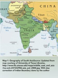
Geography of South Asia
South Asia consists of Afghanistan, Pakistan, India, Nepal, Bhutan, Bangladesh, Sri Lanka and Maldives. It extends south from the main part of the continent to the Indian Ocean. The principal boundaries of South Asia from North Are Central Asian Republics of Turkmenistan, Uzbekistan & Tajikistan, The Himalayas extend from North to North East, it also is bordered by Tibet Autonomous Region (TAR) of the People’s republic of China, Myanmar is located in the East. South Asia juts out in the sea with the Bay of Bengal located in the South East which separates it, in the maritime domain, from South East Asia, in South it is Indian Ocean and in South West it is Arabian Sea. Iran shares the land border with the region in the West.
The peculiar thing about South Asia is that these are the countries which are separated by history but united by geography. At the same time many of them have unstable borders. One of the major implication of such a state is that many of the resources, especially hydro resources, existing within the region are monolithic in nature but dispute exists in exploiting them in a cooperative manner.
Drainage systems in South Asia– There are three major drainage systems in South Asia, namely, Indus River Basin, Indo-Gangetic River system and Brahmaputra- Meghna System. The importance of these lies in the fact that many of the rivers in these systems have trans-border presence.
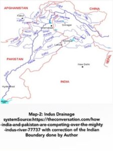
- Indus River Drainage System– 3180 km long River Indus originates in TAR, travels North-West, flows through Ladakh and Pak occupied Gilgit Baltistan then bends sharply to South-West and finally drains into Arabian Sea south of Thatta near Karachi. The total drainage area exceeds 1,165,000 km2 with annual flow of around 243 km3. In Ladakh it is joined by Zanskar River from east and in plains of Panjab it is joined by Panchnad River which itself is formed by five rivers namely, Beas, Ravi, Sutlej, Jhelum, and Chenab joining from East. Major source of water from West is from Rivers; Shyok, Gilgit, Kabul, Khurram and Gomal among many others. Indus and most of its tributaries are glacier fed. Since Indus as well as most of its tributaries are trans-border channels it has its implication. However more about it a little later. In case of Indus and Sutlej China is upper riparian, India is middle riparian and Pakistan is lower riparian. There are seven major common rivers between Pakistan and Afghanistan, with Kabul River being the major one. In case of these rivers, Afghanistan is the upper riparian and Pakistan is the lower riparian state.
- Indo Gangetic Basin–
 Although some literature talks of including Indus basin also into it but for providing a bit of clarity in this section only River Ganges and its tributaries are being spoken of. The Source of water in Ganges is from glaciers of Gangotri, Nandadevi, Kedarnath, Satopanth, Kamet, Trisul and Nandakot. Its length is 2525 kms or 2704 kms depending on which alignment is taken as the real Ganges. It is also a trans-border river as number of its tributaries originate either in Nepal or TAR and one its branches goes into Bangladesh where it is known as Padma. In Bangladesh it is joined by Jamuna (Brahmaputra) and then Meghna and finally empties into Bay of Bengal. Its tributaries are Yamuna, Ramganga, Gomti, son, Damodar and Punpun. All these are those rivers which have their origin in India. Gandak, Burhi Gandak, Kosi, Karnali, Trishuli among many others. Arun is yet another river which is part of Kosi or Sapt Kosi river Systems. All these rivers, either originate in TAR of Nepal. Karnali originating in TAR is joined by Sharada after entering India becomes Ghagra. It provides maximum water into Ganges. Mahananda, originating near Darjeeling, joins Ganges after entering Bangladesh. The basin area stretches over 1.32 million km2 of Northern region of India, Nepal, and Bangladesh. Discharge into the river is to the tune of maximum 18490 m3 and minimum 180 m3 during lean period. It provides water to 40 % of the population of India. There is a Canal from Farakka Barrage to feed into Hooghly River to improve its navigability. It is a point of dispute between India and Bangladesh but more about it later. Point to remember that in this river system China is upper riparian Nepal in some cases and in some cases, India is middle riparian and Bangladesh is the lower riparian state.
  Ganges- Brahmaputra- Meghna Basin-Enough has already been mentioned about Ganges River system in the earlier section. At Farakka (Shibganj in the district of ChapaiNababganj) the Ganges gets divided into two streams. One stream enters Bangladesh and is known a Boro Ganga. The other stream known a Bhagirathi Hooghly remains within India and finally empties into the Bay of Bengal near Sagar आइलैंड। Boro Ganga gets joined by Jamuna (Brahmaputra), upstream of town of Goalundo (in Bangladesh) and the combined river gets the name Padma. Jamuna in Bangladesh is known in India as Brahmaputra, which is created by the flow of three important tributaries from Eastern Himalaya near Sadia in Assam. These are Lohit, Dibang and Siang. Siang originates in TAR where it is known as Yarlung Tsangpo. Several other tributaries also join it in its journey. Padma joins Meghna in Chandpur district before emptying into the Bay of Bengal. While talking of journey of Meghna it commences with Barak River which originates in Manipur hills. Barak River enters Assam at Tipaimukh. Near Badarpur it divides into Surma and Kushiyara rivers and both the rivers enter Bangladesh into Sylhet Depression. Both these rivers again join above Bhairab Bazar and thereafter the river is known as Meghna. Thus, this river system consists of several Trans-Border channels, where in case of Brahmaputra, China is upper riparian, India is middle riparian and Bangladesh is lower riparian state. For Meghna River System India is upper riparian and Bangladesh is lower riparian state. For Ganges River system India is upper riparian and Bangladesh is lower riparian state. An important river in this basin is Teesta which originates in Sikkim and after travelling through West Bengal it enters Bangladesh at Dahagram and joins Jamuna (Brahmaputra) at GaibandhaFulchhari in Bangladesh. Here it is important to note that there are 54 rivers which flow into Bangladesh from India.
Conventions Controlling Sharing Water of Trans-Border Channels
UN Convention on Water Sharing of Trans-Border Channels-On 21 May 1997 the UN General Assembly adopted the United Nations Convention on the Law of the Non-Navigational Uses of International Watercourses.Incidentally it is the only treaty governing shared freshwater resources that is of universal applicability. It stipulates principles and rules that may be applied and adjusted to suit the characteristics of particular international watercourses.The Convention as 37 Articles in seven parts. Key provisions are there in Part-II, III and IV. Article-5 in Part-II stipulates equitable and reasonable utilisation of water by all riparian states. It also talks of equitable participation in use, development and protection of the water course. Article-6 talks of relevant factors and circumstances for equitable utilisation. Article-7 stipulates obligation not to cause significant harm to the water course. In other words it means that the riparian states are obliged to take appropriate measures to prevent any kind of damage to the other riparian states. Part-III talks of the principle of prior notification of planned measures being taken by a state which may adversely impact the other riparian states with a view to give adequate time to the affected state to invoke measures in accordance with Article-5/7. Part-IV talks of the protection, preservation and management of the concerned trans-border water channel. The convention was opened for signatures from 21 May 1997 to 21 May 2000. However till 2014 only 38 countries had signed and only 35 had ratified it. The Convention came into force on 17 Aug 2014. It is noteworthy that when the Convention had come up for voting China had voted against it, India & Pakistan had abstained, Nepal and Bangladesh had voted in its favour but neither have ratified it,. This state of non-adherence to an international convention by the countries of South Asia and China flags that water remains captive in this region to either a state where, ‘Might is Right’ or bilateral arrangements/ accords may help the countries to resolve their differences.
Sustainable Development Goals (SDGs)- In Sep 2015, UN General Assembly adopted the 2030 agenda for the sustainable development. It includes 17 SDGs. SDG deals with, “Clean water and Sanitation”. Although the SDGs are not legally binding, the governments are expected to take ownership and establish national frameworks for the achievements with respect to all 17 SDGs. India, Maldives, Sri Lanka, Nepal, Bangladesh, Pakistan and Afghanistan have signed the declaration on the 2030 agenda for the sustainable development. China in 2016 came with her own SDGs.
Impact of Climate Change on Availability of Water
Water availability is likely to become unpredictable leading to reduction and contamination of the water supply. Intensity and frequency of the water related natural disasters is on the rise. It needs to be noted that disasters destroy/ contaminate entire water supply. Further rising temperature leads to increase in the pathogens in fresh water. Thus climate change is causing greater water stress, especially in countries which are already water stressed like Pakistan and parts of Bangladesh & India. Rising sea levels due to melting of polar ice is further impacting the quality of fresh water near estuaries. The impact of this phenomenon is being worst experienced by Pakistan in the estuarine area of Indus as discharge volume of fresh water in Indus is quite less. By an estimate it is felt that sea ingress in Sindh has gone as high as 87 km, .
As explained in the introduction most of the countries of the region and China, not having adequate water resources of their own, are dependent on each other to optimally utilise the common resources, but in the absence of any formal international arrangements, are having disputes among themselves with a very dark shadow of China looming large on the region as China has its own water issues and she is going ahead to appropriate resources for which she is upper riparian, at will, at the cost of lower riparian states.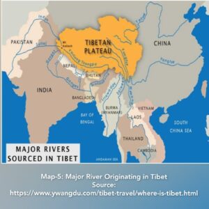
Influence of China on Water Availability in South Asia
There are almost 37000 glaciers on Chinese side of the Tibetan plateau. As such rivers which originate there, are; Indus; Sutlej; Yarlung Tsangpo (Brahmaputra); Irrawaddy; Salween; Huang He; Yangtse; and Mekong. Except Huang he and Yangtse, other rivers flow into Pakistan, India, Myanmar and Laos and form the largest river run-off from any single location. The hydrological output in Tibet is estimated to be of the order of 627 km3 per year. To get a perspective, this is about 34% of the total river water resources of India. Before the annexation of Tibet by the PRC, the entire volume of this hydrological output used to flow into lower riparian states, however, due to construction of a number of dams and also due to reduced output on account of the climate change, nowadays, only 577 km3 is transferred to lower riparian states.An important fact that needs to be taken into consideration while analysing the needs of China and her related action is that Chinais home to close to 20% of the world’s population, and has access to only seven per cent of its world’s water resources.Other factors that need to be taken into account, to appreciate the criticality of the availability of water are, severe pollution of its surface and groundwater caused by rapid industrialisation and the gap in the availability of water in the Southern region which is water-rich in comparison to the water-stressed Northern part. China isgoing for a number of dams on various rivers originating in Tibet (case in point is latest dam in Medog county near Arunachal Pradesh border on Yarlung Tsangpo (Brahmaputra)). While stated objective of all such dams has been that these are meant to generate power and use the water for irrigation purposes, but possibility of using the stored water as a weapon by the upper riparian state is always there. The Parichu incident 2004-05, clearly shows that China is quite capable to use his advantage of being upper Riparian to weaponize the water. She is also making an attempt to divert water from Indus and Brahmaputra to parched areas of Xin Jiang and Northern China. As per her ‘Five Years Plans’, the Chinese government has planned to build 120 gigawatts (GW) of new hydropower plants. China has already blocked the flow of the Xiabuqu river, one of River Brahmaputra’s Tibetan tributaries, for the Lalho hydel project. China is also building five dams on Brahmaputra river, In China’s14th Five Year Plan it was mentioned that a mega dam (sixth) on Yarlung Tsangpo in Medog Country, just 30 Km from Indian border will be built, which will be part of China’s Long Term Vision for 2035, adopted by Plenum, in October 2020 . It is also reported that they will also try to divert the Brahmaputra (Yarlung Tsangpo) Northwards, to China at the u-bend”, before it enters India. Construction of dams on Yarlung Tsangpo is going to impact the availability of water in downstream areasbecause of the sheer size of the infrastructure projects undertaken by China, poses a significant threat to the populations living downstream. Close to a million people live in the Brahmaputra basin in India and tens of millions further downstream in Bangladesh.
China has built a medium scale dam on the River Indus few miles eastward of Ali, which is the capital of Ngari prefecture and opposite Demchok in Ladakh. The structure has apparently stopped most of the river flow and likely to cause water shortage for downstream projects including the existing Tarbela dam in Pakistan that also lies on Indus . More recently China had blocked the flow of the Galwan River, a tributary of the River Shyok, thus altering the natural course of the river to prevent it from entering India. In an outreach to Pakistan, it has promised to finance and build five dams on Indus in Gilgit Baltistan, which will form the ‘North Indus River Cascade’. These dams are coming up, from North to South at; Bunji; Diamar-Basha; Dasu; Patan at Thakot. These dams will negatively affect the flow of water to lower riparian states, i.e.; India and Pakistan, especially in non-monsoon months.
It appears that China sees execution of these projects as her right, as a continuation of the historic tributary system, wherein tributary states had no right to object to the action of China and had no significant leverage in the negotiations.
In the absence of any dispute resolution in place in respect of transborder water channels, diplomatic negotiations are the only means to settle the disputes.
Relations within South Asia
AfPak Relations- There are sevencommon riversand the most important ones among them are Kabul, Khurram, Gomal. There are several other seasonal rivers. Kabul and its tributaries add almost 20-28 MAF of water into Indus. If Afghanistan starts constructing dams on common rivers, the water stressed Pakistan’s problem will get compounded. With Shahtoot dam completed and as mentioned by Jamaat Ali Shah, former Indus Water Commissioner that Afghanistan is constructing 12 multipurpose dams on common rivers, Pakistan’s water woes seem to be getting further aggravated. It has also been reported that Afghanistan is planning to build Kama Diversion Dam on Kabul River with Indian assistance and Machalgo dam on Khurram river. In fact a total of 21 projects are in progress. These projects though will help Afghanistan to get much needed relief but definitely reduce availability not only in Indus substantially but will also affect water availability in Khyber Pakhtunkhwa. In the absence of any kind of agreement between the two countries presently, it is free for all and Pakistan being lower riparian is definitely at a greater disadvantage and definitely it is to India’s advantage to build bridges with Afghanistan by providing support to Afghan endeavour to exploit her hydro resources.
Indo- Pak Water Relations- The Indus Water Treaty (IWT) of 1960 is the framework of cooperation. As per this India has resources of the three Eastern rivers, namely; Beas, Sutlej and Ravi of Indus Basin whereas Pakistan has got the waters of three Western rivers, namely; Indus, Jhelum and Chenab with India getting access to these rivers for a very limited lien as well as some non-consumptive use. It is strange that both India and Pakistan feel that it is a flawed treaty. Pakistan feels that they have been denied their legacy rights on Eastern Rivers and India feels that it neither takes note of new realities nor its dispute resolution mechanism is fair. However, it is also true that it has held for over sixty years now. Pakistan was not complaining very loudly earlier, when she was getting more water than authorised due to lack of infrastructure on India’s part to retain water authorised to her, but post Uri incident when India decided to expedite infrastructural works to exploit water that was flowing to Pakistan above her authorisation, Pakistan has started feeling the pinch. In this connection it needs to be noted that Pakistan’s problems are the consequences of her own doing. Firstly, they have not created enough storage. Pakistan has storage space of just about. 30 days as compared to India which has a storage space of 120-220 days[i] In this connection it is important that they don’t have consensus among states for new storage. Secondly, IRSA and WAPDA the two agencies known for inefficiency and corruption have failed so miserably in the management of 180 MAF of water allocated to them. Of this quantum of water only 30 % reaches the crops due to seepage and evaporation and 38 MAF gets drained into the sea[ii]. However, one great boon in disguise for India is that the IWT-1960 is between India and Pakistan, whereas the Western Rivers and Ravi of the eastern Rivers pass through UTs of J&K and Ladakh, thus de-facto Pakistan accepts the legitimacy of accession of the erstwhile Princely State of J&K to India. This fact India needs to exploit besides expeditiously completing the infrastructural works to exploit the water as authorised to her. India also have two opportunities. One on the western front where by employing water based diplomatic initiative India can win the confidence of Afghanistan by completing those 12 promised dams on River Kabul and its tributaries and reduce the support base of Pakistan in Afghanistan which Pakistan has been trying to use as a strategic depth. 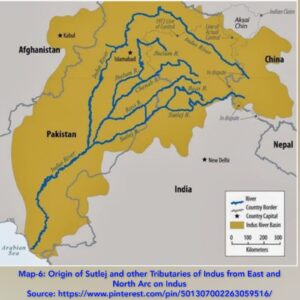 The second is wherein they need to convince Pakistan that China is stealing water authorised to her by building dam on Indus in TAR and also attempting to divert its water towards Xin Jiang and thus there is a need to come together to challenge PRC. For such an objective, India should approach the people of Pakistan to convince them because Pakistan establishment is so much under the influence of PRC that it is unlikely to raise voice against China. India also needs to question Chinese attempts to weaponize waters of Parichu ( as they did in 2004-5) and stealing water by constructing dam in Zada Gorge on Sutlej[iii].
India Bangladesh Relations- There are 54 common rivers between India and Bangladesh. There are three issues which had been a source of disagreement between the two countries.These are as follows:-
- Sharing of Ganga waters– Despite differing perception on issue finally an agreement was signed in 1996, “Indo- Bangladesh Treaty of Ganges waters-1996”. This amicably settled the issue. The treaty will come up for review in 2026.
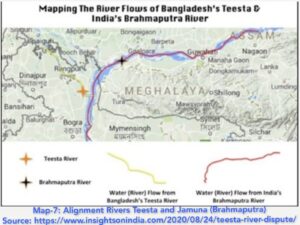
- Teesta Dispute– Sharing of waters of Teesta, originating in Sikkim, traversing through West Bengal and finally joining Jamuna in Bangladesh, is a long standing demand of Bangladesh. There is a differing perception of needs of the two countries and the possible alternate solutions. It is however, is of the interest of India that the issue is resolved quickly, lest China jumps into the fray, as Bangladesh is discussing a proposal of China to dredge and embank large portion of Teesta and invest about $1 billion as part of their BRI project[iv]. China coming so close to Chicken’s neck would be a threat to India.
- Tipaimukh Dam-
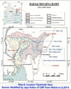 It is a proposed dam on Barak River in Manipur. It is hanging fire since 1974, when it was decided to construct it to manage flood situation in parts of Assam in India and Sylhet in Bangladesh. However Bangladesh is now apprehensive about the availability of water downstream of the dam. Like Teesta it also has potential to impact the Indo Bangladesh relations and as such needs to be resolved quickly.
Way head– There is a framework agreement for greater cooperation in water management signed between the two countries in 2011. Thatneeds to be progressed to resolve all outstanding issues. Such cooperation will also help India to build a common front with Bangladesh against Chinese attempts to appropriate waters of Yarlung Tsangpo, to which both India and Bangladesh are legal claimants, being lower riparian States.
Indo Nepal Water Relations- Nepal though occupies only 14.72 % of the Ganges Basin but contributes about 38.1% of its water[i]. However there are many issues, mainly that of flooding and consequent inundation which impact the water relations between the two countries. Nepal also feels that the root cause of her problem is that India is going for a number of infrastructural constructions to exploit common water resources without consulting Nepal[ii] . The history of water relations between the two countries date back to 1920 when Sharada dam on River Mahakali was planned. Subsequently, in 1954 Kosi Agreement was signed, in 1959 Gandak Agreement was signed, in 1991 Tanakpur MoU was signed and finally in 1996 Mahakali Treaty was signed. There are a number of projects, which are in various stages of discussion/ planning/ execution. It is of mutual interest, that both countries resolve quickly all issues and exploit vast potential of common hydro resources for common good. For both it is an opportunity. For Nepal it is to improve its economy by monetising hydro resources and for India, it is to benefit from the power generated from hydro resources of Nepal, which she can have lien on. By an estimate, Nepal hydro resources have a potential for 42 GW of economical exploitation[iii] . In this connection it would be beneficial to Nepal to follow Indo- Bhutan power sharing model, which has helped Bhutan to graduate to middle income group by selling power to India. Nepal can likewise improve her economic condition because she has greater potential as compared to Bhutan; who has hydro power potential of only 30000 MW. Income per capita comparison of India, Nepal and Bhutan flags this issue clearly. In 2020, income per capita on the basis of purchasing power parity of the three countries was as tabulated below:-
Table-1
| Ser Number | Country | Income per capita |
| 1. | India | $6390 |
| 2. | Bhutan | $ 10480 |
| 3. | Nepal | $4066 |
Source: https://data.worldbank.org › indicator › NY.GDP.PCAP.CD
Conclusion
It can therefore be concluded that the hydro resources of South Asia are monolithic in nature. The growth in population with reduced availability of water on account climate Change is reducing the overall availability of water with the countries of the region. The attempts of China to appropriate resources in defiance of the international conventions is adding to the criticality. The prevailing situation when extrapolated, centre stages a future which is likely to be quite difficult. It throws up new challenges to augment supply of potable water within South Asia. Threat to India’s effort to optimise her legitimate resources is quite substantial. However, India has opportunity to create a situation where Bangladesh, India, Nepal and Bhutan together can come out with a model which can be ‘win- win’ for all. To challenge China from usurping resources meant for lower riparian states, India needs to make a common front with Pakistan, Nepal and Bangladesh. It indeed is a diplomatic challenge but it is a ‘Must do’ act. Pakistan’s problem with Afghanistan is similar, where India has an opportunity to help Afghanistan to exploit her resources, which will also help India to bring Pakistan to realise that her destiny lies in South Asia and China’s efforts to appropriate common resources need to be challenged. End Notes
Note – First published in the ‘Strategic Year Book-2022’ of USI, being Pub with due acknowledgment to the US, New Delhi.
Author –  Maj Gen AK Chaturvedi, AVSM, VSM (Retd) is a retired Indian Army General Officer who has served in Jammu & Kashmir, NE, Andman Nikobar on various appointments at Command and Army HQs. . He is Vice Chairman of Think Tank, “STRIVE”, after retirement is pursuing his favorite hobby of writing for newspapers, journals, and think tanks.
Disclaimer: The views expressed are those of the author and do not necessarily represent the views of the organisation that he belongs to or of the STRIVE.
[i]Internet upload: https://www.worldometers.info/world-population/southern-asia-population/
[ii]The United Nations World Water Development Report 2015, “Water for Sustainable World” and uploaded on https://unesdoc.unesco.org/ark:/48223/pf0000232947
[iii]Stephen C. McCaffrey, “Convention on the Law of the Non-Navigational Uses of International Watercourses”, New York, 21 May 1997, uploaded on https://legal.un.org/avl/ha/clnuiw/clnuiw.html
[iv]Shawahiq Siddique, “UN Watercourses Convention is good for South Asia” dated 18 Aug 2014, uploaded on https://www.thethirdpole.net/en/climate/un-watercourses-south-asia/
[v]China:United Nations sustainable development Goals- Policy Priorities &Business Strategies, uploaded on https://www.conference-board.org/ChinaSustainabilityGoals
[vi]Aditi Phadnis, “Water conflict in Kashmir”, Business Standard, 16 May 2005
[vii]A UNICEF Report: “Water and Global Climate Crisis: 10 Things you should know” dated 18 Mar 2021 and uploaded on http://www.unicef.org/stories/water-and-climate-change-10-things-you-should-know
[viii]Brook Larmer, “The Big Melt”, pub in the National Geographic Magazine in April 2010.
[ix]China, Tibet and Strategic Power of Water, pub in Circle of Blue/ Water News dated 08 May 2008 and uploaded onhttps://web.archive.org/web/20080702122515/http://www.circleofblue.org/waternews/world/china-tibet-and-the-strategic-power-of-water/
[x]“Introduction to water resources of Tibet”, pub in Tibet Nature Environmental Conservation Network dated 02 Jun 2014 and uploaded on https://tibetnature.net/en/introduction-water-resources/
[xi]“Introduction to water resources of Tibet”, pub in Tibet Nature Environmental Conservation Network dated 02 Jun 2014 and uploaded on https://tibetnature.net/en/introduction-water-resources/
[xii]Christophe Jaffrelot , Vijey Ganesh R S, “Chinese dam projects on Brahmaputra are a threat to lives and livelihoods downstream”, Pub in Indian Express dated 23 Nov 2020.
[xiii]Maj Gen AK Chaturvedi, AVSM, VSM (Retired), “Attempts of China to Steal Water from Lower Riparian States” uploaded on 09 Feb 2021 on https://striveindia.in/attempts-of-china-to-steal-water-from-lower-reparian-states
[xiv]Sutirtho Patranobis ,” China blocks Brahmaputra tributary, impact on water flow in India not clear”, pub in Hindustan Times dated 01 Oct 2016 and uploaded on https://www.hindustantimes.com/india-news/china-blocks-brahmaputra-tributary-impact-on-water-flow-in-india-not-clear/story-QVAYbO2iOBFUSynwwpyneN.html
[xv]A Third Pole. Net, “ China’s plans for gigantic Brahmaputra dam strains relations with India further” dated 04 Dec 2020 and uploaded on https://www.thethirdpole.net/2020/12/04/chinas-plans-for-gigantic- Brahmaputra-dam-strains-relations-with-India-further/
[xvi]Maj Gen AK Chaturvedi, “China’s Exploitation of Yarlung Tsangpo: Consequences for Lower Riparian States”, pub by StriveIndia.in dated 28 Jan 2021 uploaded on https://striveindia.in/chinas-exploitation-of-yarlung-tsangpo-consequences-for-lower-riparian-states/
[xvii]Christophe Jaffrelot , Vijey Ganesh R S, “Chinese dam projects on Brahmaputra are a threat to lives and livelihoods downstream”, Pub in Indian Express dated 23 Nov 2020.
[xviii]Senge H. Sering, “China Builds Dam on Indus near Ladakh” and uploaded on https://idsa.in/system/files/jds_4_2_shsering.pdf
[xix] Vishnu Som, “Chinese Bring In Bulldozers, Disturb Flow Of Galwan River: Satellite Pics “
dated: June 19, 2020 and uploaded on https://www.ndtv.com/india-news/ladakh-face-off-india-china-chinese-bring-in-bulldozers-disturb-flow-of-galwan-river-2248420
[xx]An IANS Report, “Chinese funded NorthIndus River cascade a Himalayan blunder for Pakistan”, pub in Business Standard dated 22 May 2017
[xxi]Joydeep Gupta, “Indus Cascade a Himalayan Blunder”, pub in The Third Pole dated 22 May 2017, uploaded on https://www.thethirdpole.net/en/climate/indus-cascade-a-himalayan-blunder/
[xxii]Sudha Ramachandran, “India’s controversial Afghanistan Dam”,pub in The Diplomat dated 20 Aug 2018.
[xxiii]Fawad Ali, “Pakistan officials call for water agreement with Afghanistan” pub in thethirdpole.net dated 21 Sep 2-16 and uploaded on https://www.thethirdpole.net/en/energy/pakistani-officials-call-for-water-agreement-with-afghanistan/
[xxiv]IBID xxiii
[xxv]Maj Gen AK Chaturvedi, “Water a Source of Future Conflicts”, pub by Vij Books India Ltd, 2013, P-124 and P-174.
[xxvi]Nilova Roy Chaudhury, “China quietly builds a barrage on Sutlej”, pub in Hindustan Times dated 30 June 2006.
[xxvii]Maj Gen AK Chaturvedi, “Indo Bangladesh water relations”, pub by STRIVE dated 11 May 2021 and uploaded on https://striveindia.in/neighbour/page/4/
[xxviii]Poudel S. N.(2009) and edited by Dhungel D.N. and Pun S.D. , “ Water resources utilisation: irrigation. In The Nepal–India Water Relationship: Challenges” , Pub Institute for Integrated development Studies, Kathmandu, Nepal, pp: 99-123 during 2009.
[xxix]Dharmaraj Bugale, “Nepal India Water Cooperation: Consequences of Mutuality or Hegemony”, pub in Official Journal of World Water Council, Vol 22, Issue-6 dated 22 Dec 22 and uploaded on https://iwaponline.com/wp/article/22/6/1098/77973/Nepal-India-water-cooperation-consequences-of
[xxx]Herath Gunatilake, Priyantha Wijayatunga and David Roland Holst, “Hydropower Development and Economic Growth in Nepal pub by ADB South Asia Working Papers Series No 70 of June 2020 and uploaded on https://www.adb.org/sites/default/files/publication/612641/hydropower-development-economic-growth-nepal.pdf
An extremely well researched, analysed and presented article by an accomplished author. Please accept our heartiest congratulations on the enormous effort.
Warm regards